6. Strong Government Action: Government of any country is a law making body. It should ensure that proper laws are there to punish the culprits. Illegal cutting of trees, poaching/trading of wild animals for commercial purposes, are some of the punishable offences, that should be closely monitored.
7. Environmental Awareness: Last, but not the least, environmental education is very important for each individual. Such education programmes should be launched by the government from time to time to increase awareness among the people and educating them on environment and related issues. Schools and colleges should also have basic courses related to environment and conservation in their curriculum.
How can Remote Sensing Technology and GIS Help in Forest Management?
Satellite remote sensing has the potential to locate and map the spatial configuration of a landscape and analyze the changes taking place over a period of time.
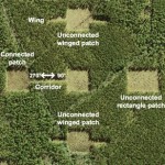
Satellite data at various resolutions offer the scope to assess the extent of forest fragmentation. However, satellite data can only give us information regarding the location, extent and type of forest and further processing is needed to quantify and map forest fragmentation. (Turner and Gardner 1991; Gustafson 1998)
Remotely sensed data, in conjunction with Geographic Information System (GIS), has been successfully utilized to quantify forest loss as well as forest fragmentation. Lovejoy et al. (1983, 1984) have also carried out a large-scale fragmentation study in Amazon forests. In GIS, domain modeling can be done to achieve conservation and planning strategies.
Remote areas which are not accessible by humans can be observed through remote sensing. Forest fragments exist as large patches and also as several small patches. The exact size and shape of the fragment is important which can be analyzed in Geographic Information System (GIS) domain. Further analysis is based on the fragmentation metrices (such as size, shape, area, perimeter, mean patch area and mean patch perimeter). Each patch harbours biodiversity of equal importance. Hence, both large and small forest fragments should be taken into consideration for conservation.
Using multi-date satellite data, one can keep a close record of the status of fragmented forest. For long term monitoring, establishment of permanent plots in the identified areas is required. The tree species can be counted and tagged and time-to-time monitoring can be done. Seedlings and saplings of the tree species can also be taken into account, which reflects about the structure of the forest. They should be allowed protection for their growth, as they are more likely to be trampled. Biomass monitoring is also necessary.
Small forest fragments are a sub-set of large fragments. They have small habitats and support small number of plant and animal species. The disadvantage of smaller patches is they are more likely to be subjected to illegal logging and over-exploitation of forest patches. Large forest fragments provide larger habitat area for animals and plants. Forest interior species will thrive well. More number and more varieties of species will inhabit them. They enhance the regional biodiversity. Species composition should be studied in both types of patches.
Species of commercial importance like Shorea robusta, Acacia catechu in the tropics are more likely to be exploited for their needs; thus, patches harbouring these types of species should be on priority. Disturbance begins along the edges of the large forest fragments; hence, these patches should be protected along the edges. Large forest fragments should be prevented from further degrading and diminishing. Existence of small clearings is noticed in between the large forest fragments, such areas should be filled by planting trees of importance.
Developmental activities should not take place in and around the vicinity of forest fragments. Building of roads and railway-lines through the forest patches should be avoided. A buffer area should be spared and cordoned off. Planting trees in the buffer area would provide an extension of suitable habitat for plants and animals. Public entrance should be stopped. Grazing should be prohibited. In GIS modeling, alternative routes can be analyzed (minimal disturbance) and be represented on a map for transportation and public use.
The need of the hour is to take steps to save these forest remnants. By saving them, we would at least help in saving a part of biodiversity and left over habitats for plants and animals. The forest fragments, thus, provide us a last ray of hope of conserving them.
About the Author:
Being an environmentalist by profession, Laxmi N. Goparaju has worked extensively with Forestry & Ecology Division (FED) of National Remote Sensing Centre (NRSC), Department of Space, India. She holds a doctorate in Environmental Science & Technology from Jawaharlal Nehru Technological University (JNTU), Hyderabad. The topic of her thesis, “Community Diversity Assessment in Vindhyans using Remote Sensing and GIS” formed a part of the Indian Space Research Organisation’s Geosphere Biosphere Programme (IGBP) that addressed issues related to global warming at regional and global level. She can be reached at laxmi@thinktosustain.com.


